Aviation Weather Route Planner
- Категория: Weather
- Дата выхода: 2015-10-31
- Текущая версия: 5.5
- Adult рейтинг: 4+
- Размер файла: 35.24 MB
- Разработчик: Flygo-Aviation Ltd
- Совместимость: Требуется iOS 14.0 или выше.
- Кол. оценок: 20
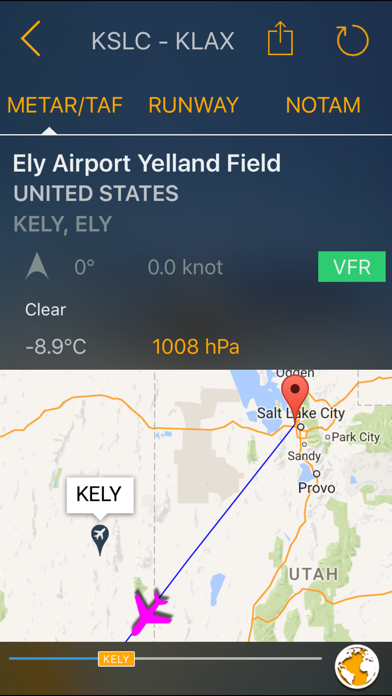
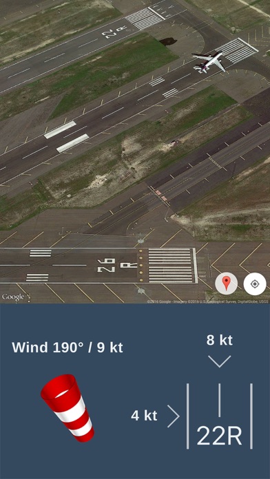
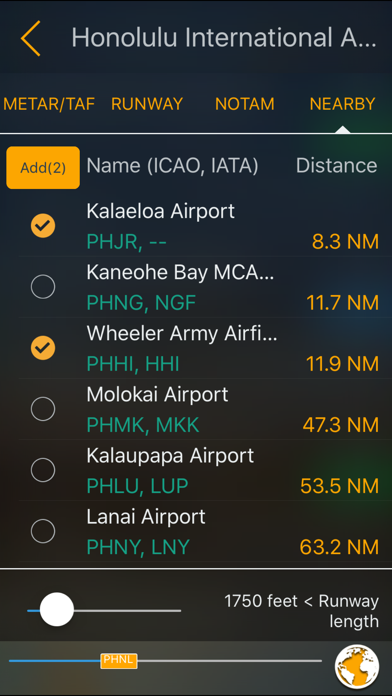
Get all weather forecast and alternate airport data during your flight. This simple and useful application was developed for pilots to save time and get accurate weather data! Try this weather map now for free and explore the new features of the recently updated weather forecast app for pilots. You can also store weather information offline which helps you to use this weather app abroad or in remote areas. The app complies with EASA-FAA Guidelines and Specifications which is available for pilots all over the world. ACCURATE WEATHER FORECAST Be always up-to date with accurate weather data during your flight. Current weather information are available in METAR and TAF and visible on the map. The app provides you live on-the-go forecast (stored offline) to keep your aviation always ready for any circumstances! ROUTE TRACKER – INCREASED SAFETY The app automatically downloads all alternate airport data along each route for increased safety. If a pilot can’t land at the chosen airport, the app suggest you airports (with weather information) nearby which are close to your route on the map. Thus, you’ll be always ready for an unplanned landing. 200.000+ AIRPORT DATA Weather information for 200.000+ Airports (even in offline mode) - grouped by name, ICAO code or your current location:* You can get access to a global database on the map which contains weather data about airports worldwide on your iOS device, no matter where you are. You can set custom filters to the airport data and see only the information you need on the map. AUTOMATIC CALCULATION OF US UNITS AND METRICS Tired of always calculating and switching between different units? FlyGo’s Avitation Route Planner app solved this issue for pilots. We’ve added the US units and metric units to the app which convert and calculate instead of pilots. AUTOMATIC WIND CALCULATION Wind makes flying always challenging for pilots. But our users don’t need to precalculate the impact of wind because a built-in automatic wind calculator already calculates the effect of the wind which makes your route safer and easier. PLAN YOUR FLIGHT ROUTES With our app you can plan your flight and see any alternate routes considering the given circumstances and weather data worldwide. Be ready for anything during your flight! METAR AND TAF WEATHER DATA The app provides you accurate and current live Raw and Decoded METAR and TAF data about every airport in the database. You will get all weather forecast information on one screen. NOTAM INFORMATION Get notified about possible hazards along your route both in the air and on the ground. You can choose between raw and reported forecast data. FIND NEARBY AIRPORTS Nearby airports are listed and you can add them if necessary. ADDITIONAL AIRPORT INFORMATION PROVIDED FOR PILOTS --- RUNWAY INFORMATION - receive notifications and alerts about the runway you want to land on. Avoid surprises and activate these notifications. SUNRISE AND SUNSET - It matters which part of the day you are flying. Get accurate information of sunrise and sunset at different airports and you can prepare for the day or night situation, too. ELEVATION - Accurate Latitude, Longitude and Elevation data of the airport. TIME ZONES: Automatic Time Zone calculating depending on the chosen airport’s zone. Enjoy the app & FLY SAFE! The FlyGo-Aviation Team