UK Parks & Forests GPS OS Maps
- Категория: Navigation
- Дата выхода: 2011-02-03
- Текущая версия: 4.2
- Adult рейтинг: 4+
- Размер файла: 36.67 MB
- Разработчик: Flytomap
- Совместимость: Требуется iOS 8.0 или выше.
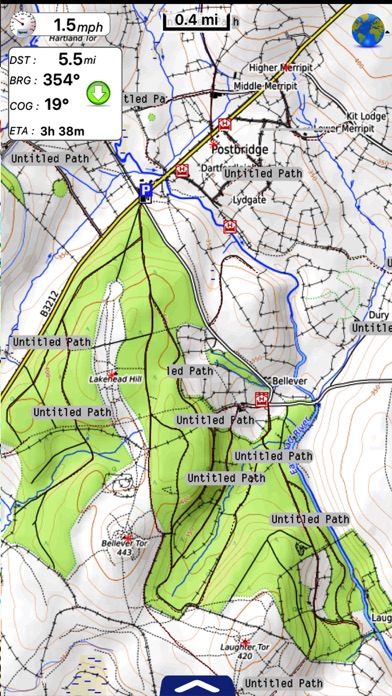
!! TRY before BUY !!! Try now the new FlyToMap web viewer to see all available maps worldwide !!! Visit viewer.flytomap.com UK Parks map application is extremely advanced contains embedded electronic charts with all information collected from the National Park Service and local sources. The maps contain all multiple trails (Hiking, biking, Stairway trails, Bicycle trails, Equestrian trails etc.,) and Point of interests (POI) like Campgrounds, Eating places, Ranger Stations, Picnic areas, Boat/Canoe launching, Parking areas etc., which are provided depending on the relevant park areas they exists. “Covers all Trails, Lakes and Rivers within the Parks” “Covers complete park boundary from (NPS)” “Elevation Contours with 10 meters interval” “Mountain Summits” “All Roads and Railways from TIGER” PARKS COVERED: Dartmoor National Park, Exmoor National Park, The Lake District National Park, North York Moors National Park, The Peak District National Park, Yorkshire Dales National Park, Brecon Beacons National Park, Cairngorms National Park, New Forest National Park, Northumberland National Park, Pembrokeshire Coast National Park, Snowdonia National Park, The Broads National Park, Ashton Court Estate - (Bristol), Hyde Park (London). Features: GPS Compass Tracking (Record & Email) Add Favorites (Unlimited) Advanced Search Search location using Lat/Lon Check Speed/Distance/Direction towards a destination Map User Guide Offline Map …More… A Travel guide is provided for easy reference, you can use it without any Active Internet connection! NOTE: • Continued use of GPS running in the background can dramatically decrease battery life. • Turn off GPS when not in use